


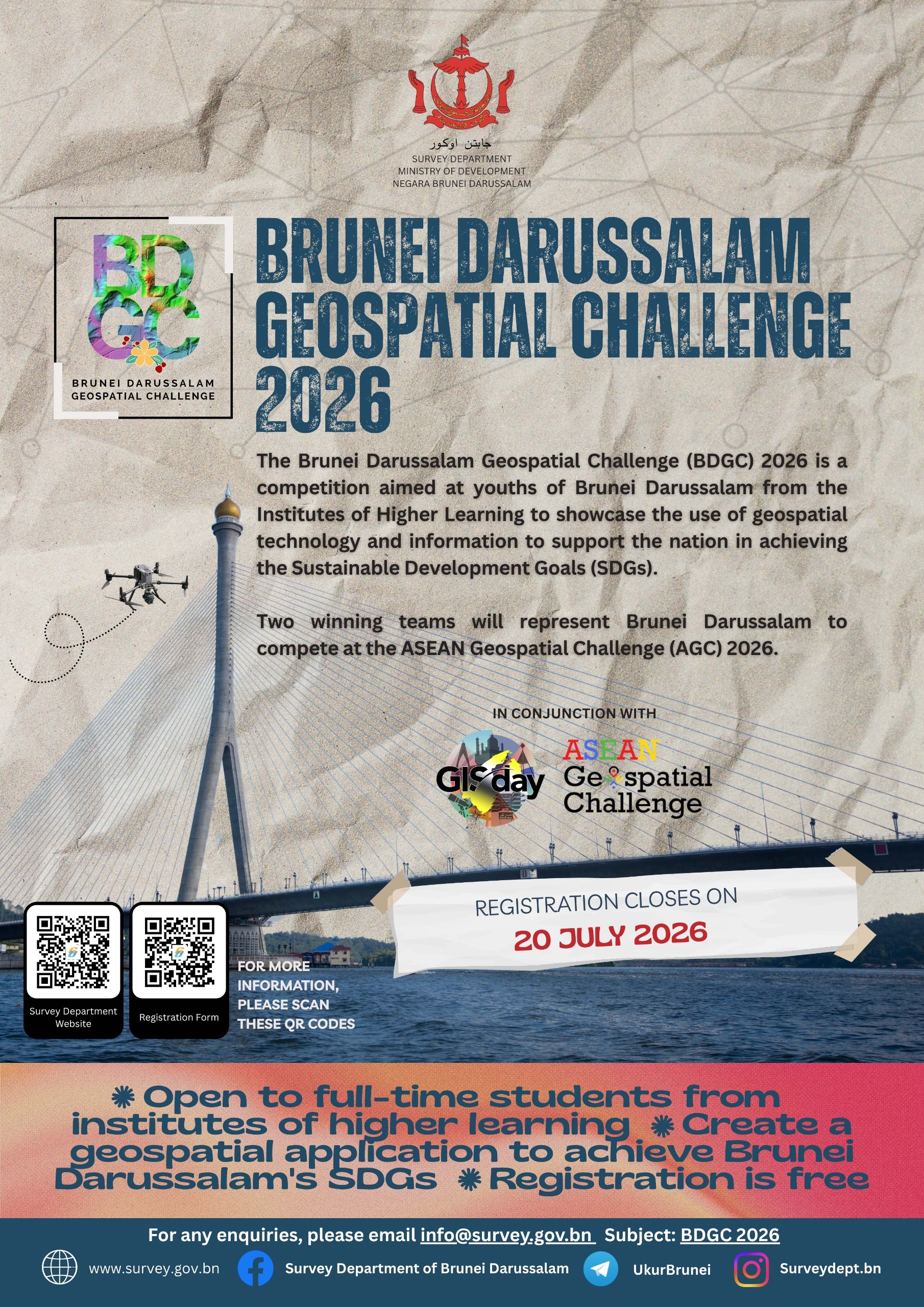
Calling All Full-Time Students from Institutes of Higher Learning
Ready to turn your ideas into real-world impact?
Join the Brunei Darussalam Geospatial Challenge 2026 (BDGC 2026) and showcase how geospatial technology can help Brunei achieve the Sustainable Development Goals (SDGs).
This national competition provides an exciting platform for students to apply innovation, creativity and technical expertise towards solving real-world challenges.
🏆 Why Join?
Meaningful Impact
Work on innovative solutions that contribute towards Brunei Darussalam's Sustainable Development Goals (SDGs).
Showcase Your Talent
Demonstrate your creativity, innovation and technical skills through geospatial applications.
Expand Your Network
Gain valuable experience while connecting with fellow students and industry professionals.
🌏 Represent Brunei on the ASEAN Stage
The TWO winning teams will earn the honour of representing Brunei Darussalam at the ASEAN Geospatial Challenge (AGC) 2026.
Compete with outstanding teams from across ASEAN and showcase Brunei's innovation and geospatial capabilities on the regional stage.
📅 Important Dates & Resources
📁 Forms & Documents
Registration Form ⬇ Project Submission Form ⬇ Declaration of Original Work ⬇ Declaration of Student Identity ⬇ Important Notes for Participants ⬇ Terms & Conditions ⬇ Project Submission Template ⬇🗓 Challenge Timeline
22 June – 20 July 2026
30 July 2026
15 August 2026
16 September 2026
18 November 2026
❓ Frequently Asked Questions
Find answers to common questions about team eligibility, competition dates, datasets, resources and submission requirements.
01 Would it be acceptable for our team to be comprised of students from different educational institutions? +
Yes, it is acceptable. As long as your team members fulfill the criteria in the Terms and Conditions, especially under the Eligibility clause:
Please let us know if you intend to combine with other local educational institutions, as this option is not available in the registration form.
02 Could you confirm the key dates for the competition? +
- Registration opens: 22 June 2026
- Registration closes: 20 July 2026
- Participants' Briefing: 30 July 2026
- Project Deadline & Submission: 15 August 2026
- Project Presentation: 16 September 2026
- National Prize Presentation: 18 November 2026
Any changes to the dates will be informed through our website and email.
03 Will participants be provided with any datasets, tools, or other resources for the competition? +
You can email your request to info@survey.gov.bn to obtain the datasets or resources. The Secretariat will contact you to get further details.
Please note this is based on, but not limited to, the size of the Area of Interest (AOI), type of data and approval of the Surveyor General.
04 Are teams expected to develop a functional product or solution, or is the poster the only required deliverable? +
The main deliverables or submissions of the challenge are:
- 1 write up
- 1 poster
- 2 minutes video clip
- 1 presentation
Please refer to the Important Notes for Participants document.
Teams are not required to create or develop a full-blown product or application. Teams are required to present a concept of the ideas with evidence to show how the proposed geospatial technology or information are being used to support the nation's SDGs.
This challenge is a great platform for students to show their potential, interest and technical knowledge in the geospatial field, while also relating it to the SDGs.
📢 Gather Your Team and Join the Challenge!
Don't miss this opportunity to make an impact, challenge yourself and contribute towards a smarter and more sustainable future.